From our field notes
Kubu Island, Botswana: Driving the Makgadikgadi Salt Pans by 4x4
Published 30 July 2026 · updated 30 July 2026 · 8 min read
By Clément Lacaille, publisher · our method
In the middle of the Makgadikgadi salt desert, in north-eastern Botswana, a granite outcrop bristling with baobabs rises out of nowhere: Kubu Island. No island, no water for kilometres in any direction — just a white expanse fading into the horizon and the silhouettes of trees several centuries old. It's one of the most spectacular, and least known, detours on a Botswana road trip, reachable by rental 4x4 without a compulsory guide, provided you prepare the pan crossing properly.
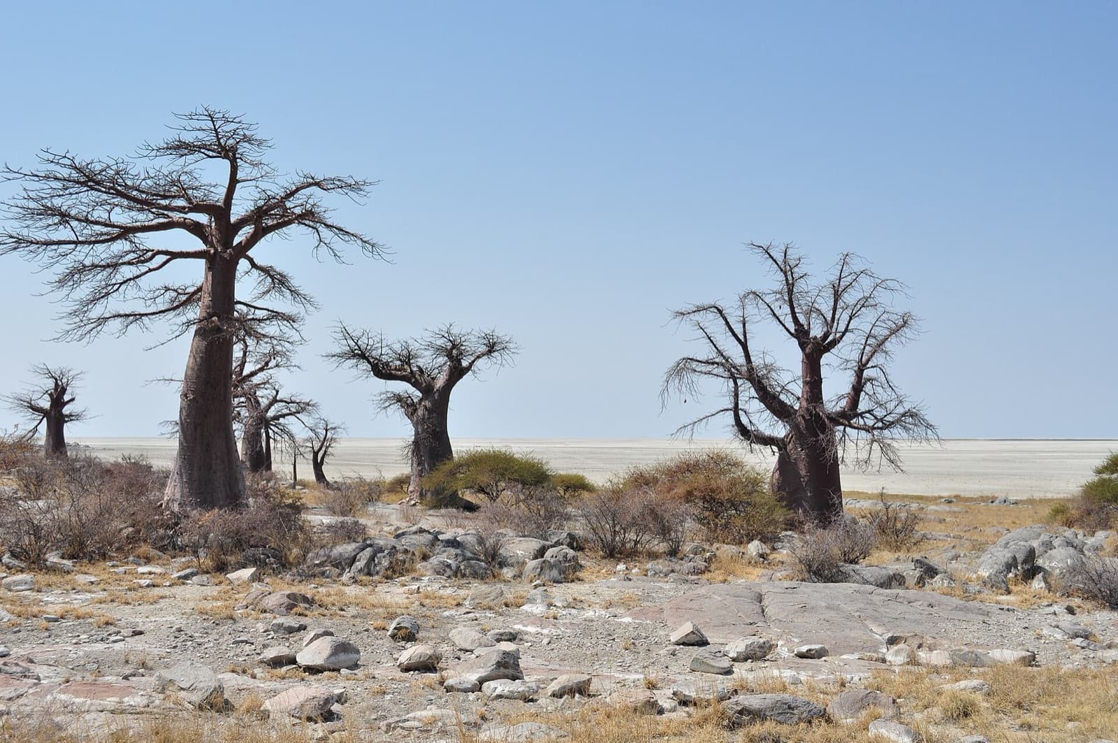
Kubu Island, a granite outcrop in the middle of the salt
Kubu Island (or "Lekhubu") isn't an island in the literal sense: it's a rocky outcrop some ten metres high, sitting on the south-western edge of Sua Pan (also spelled Sowa Pan), one of the two great pans that make up the Makgadikgadi salt desert. The contrast is striking: granite rock, streaked with fossilised bird droppings and studded with baobabs (Adansonia digitata), drops straight into a white, cracked salt crust that stretches to the horizon — no tree, no landmark.
It's this almost lunar landscape, combined with absolute silence and sunrises unlike anything else in southern Africa, that has made Kubu Island a cult site for independent travellers and photographers — without ever becoming a mass destination, for want of easy access.
Getting there by 4x4: the route from Nata or Gweta
The classic access route starts at Nata, on the tarred road linking Francistown and Maun. About 10 km past Nata heading towards Gweta, a dirt track branches off south: it leads to Kubu Island over nearly 90 km, skirting then crossing the edge of the pan through the villages of the Mmatshumo area. Allow two to two-and-a-half hours of slow driving on a sandy, sometimes corrugated track — a high-clearance 4x4 is essential, a sedan won't make it.
There is no fuel station or supply point between Nata and Kubu Island: fill up before leaving the tarred road, with a comfortable margin, and carry more water than you think you'll need. Few vehicles use this track; in the event of a breakdown or getting stuck in sand, help won't arrive quickly.
Caution on the pan: when to go, and when to turn back
The dry season, roughly May to October, is the only sensible window for venturing onto the Makgadikgadi pans: the salt crust is then hard and able to bear a vehicle's weight. In the rainy season (November to April), that same crust can break under a vehicle, which then sinks into the saline mud beneath — a bog-down you can't get out of alone, one that can strand a 4x4 for hours or damage it seriously. Even in the dry season, after recent rain, stay off the open pan and stick to the firm tracks around its edge.
The second trap is less dramatic but just as real: navigation. On the pan, tracks fork, cross and sometimes vanish under the wind, with no visual landmark for kilometres. Reliable offline navigation (such as Tracks4Africa, as for a Namibia self-drive) is strongly recommended, along with telling someone your planned route and expected arrival time.
Camping on the island: full self-sufficiency
Kubu Island is a national monument that has been managed since 1997 by the Gaing O Community Trust, representing the community of Mmatshumo and neighbouring villages. There is no lodge and no shop on site: camping is the only option, spread across a dozen pitches tucked among the rocks and baobabs, with simple pit toilets and no other facilities. Everything has to be planned in advance — water, food, firewood or gas, bags to carry your rubbish back out.
An entry fee and a camping fee are collected on site by a trust warden, in the order of BWP 150 per person per night for international visitors, plus a vehicle fee — rates change regularly and are worth reconfirming before departure, for instance with your 4x4 rental company in Maun or Kasane. These modest sums fund the site's upkeep directly and go to the community that manages it.
Thousand-year-old baobabs on a vanished lake
The baobabs of Kubu Island aren't just remarkable trees: some rank among the oldest known individuals of their species, and their very presence tells the geological story of the pan. A study by Frank Riedel and co-authors, published in 2012 in the journal Quaternary International, radiocarbon-dated several of the island's baobabs to reconstruct the evolution of the Makgadikgadi palaeolake: it shows that a permanent lake still covered the site in the early centuries of the last millennium, before the region dried out to form today's salt pan.
Walking among these trees, then, is literally walking on the bed of a vanished ancient lake — one of the largest in southern Africa during the Pleistocene. That depth of time, almost tangible in the site's silence, explains why so many travellers describe Kubu Island as one of the most historically inhabited places in all of Botswana, even though not a soul is around.
What to do there: sunrise, quad biking and starry skies
Kubu Island's essential ritual is sunrise and sunset on the pan: a few steps from camp are enough to face a 360° horizon with no trace of anyone else. At night, with almost zero light pollution, the starry sky rivals Namibia's NamibRand — reason enough to stay two nights rather than one.
For those who want to explore more of the pan without heading out alone in a 4x4, guided quad-bike excursions are offered on the Gweta side, on the neighbouring Ntwetwe Pan, by operators based at Planet Baobab or through lodges in the area — a good way to pair self-sufficient travel with an accompanied look at the salt desert.
Fitting Kubu Island into a Botswana road trip
Kubu Island slots naturally into a route linking Nata (or a loop from Kasane and Chobe National Park) to Maun and the Okavango Delta: a one- to two-night detour, best placed after the tarred road and before heading back onto track towards the Central Kalahari or Moremi. It also makes an excellent transition stop to build confidence on sand and isolated tracks before tackling more demanding parks.
Our Botswana guide details how to string this detour into the rest of a self-drive itinerary, campsite bookings included.
Travel tips
Get our independent-travel tips by email
The house methods — costed budgets, driving, itineraries — straight to your inbox. Instant bonus: our free excerpt “The 7 mistakes to avoid on a first Namibia road trip” and the current promo code.
No time to do it yourself?
A professional can take care of it: tailor-made trip, equipped 4x4 rental or a local guide. Describe your plans and, with your consent, we pass them on to partner professionals.
1. What you need
Before you go
Readers' questions
Can you get to Kubu Island without a guide, in a rental 4x4?
Yes, access is unrestricted in a rental 4x4, with no compulsory guide. You do need a high-clearance vehicle, enough fuel and water (no supply point between Nata and Kubu Island), and good preparation for navigating the pan tracks.
What's the best season to visit Kubu Island?
The dry season, roughly May to October, when the pan's salt crust is firm and driveable. In the rainy season the crust can break and a vehicle can sink into saline mud: it's best to avoid the open pan even in the dry season, right after rain.
Can you sleep on site at Kubu Island?
Yes, camping only: the dozen pitches managed by the Gaing O Community Trust have pit toilets but no other facilities. Arrive fully self-sufficient (water, food, energy) and pay a modest entry and camping fee on site.
How long does the drive from Nata take?
Allow two to two-and-a-half hours on a sandy, corrugated track over about 90 km from the tarred Nata-Gweta road, 4x4 only. There's no fuel station or assistance on this stretch, so leave with a full tank and generous water reserves.