From our field notes
Tongariro Alpine Crossing on a self-drive trip: parking, shuttles and logistics
Published 27 July 2026 · updated 27 July 2026 · 7 min read
By Clément Lacaille, publisher · our method
It is New Zealand's most famous day hike — and an apparent headache for anyone travelling by car: the Tongariro Alpine Crossing is a 19.4 km point-to-point traverse that does not return to its start, with deliberately dissuasive parking at both ends. The solution is well-oiled: sleep nearby, leave the car at your accommodation and chain the shuttles. Here is the full logistics, plus what the volcano itself — an active one — requires you to know before crossing New Zealand's 'Mordor'.
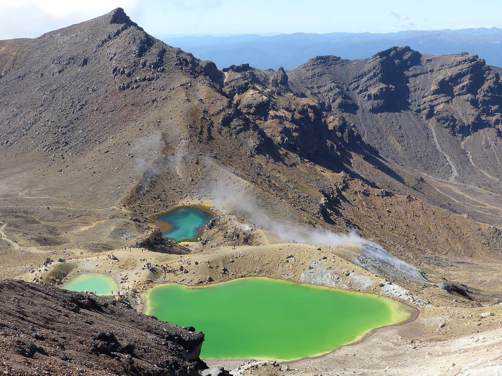
The basic problem: a traverse, not a loop
The Crossing starts from the Mangatepopo car park (1,120 m), climbs the saddle between Tongariro and Ngauruhoe — Peter Jackson's Mount Doom —, skirts the Emerald Lakes and descends interminably to Ketetahi (760 m), 19.4 km away. So you must solve the equation: how do you get your car back at the other end?
The park has decided for you: parking at the Mangatepopo trailhead is time-limited (around four hours, far too short for the traverse), precisely to stop people leaving cars there all day. The standard answer is the shuttle: you park at your accommodation or at park-and-ride lots, a shuttle drops you at Mangatepopo at dawn and picks you up at Ketetahi in the afternoon. Book by the day before at the latest, and confirm the last pick-up time.
The logistics that work: where to sleep, where to park
Three bases share the motorised hikers: National Park Village (the widest choice of shuttles and lodging, 15 minutes from Mangatepopo), Whakapapa Village (at the foot of Ruapehu, inside the park itself) and the Turangi area to the north (handy for continuing to Taupo). All offer accommodation-plus-shuttle packages that settle the vehicle question: the car sleeps in the hotel car park.
The typical day: up before dawn, drop-off at Mangatepopo between 6 and 8am depending on season, 6 to 8 hours of walking for 19.4 km and about 800 m of climb, pick-up at Ketetahi and return to base in late afternoon. The next day the car resumes its role for Taupo, the Forgotten World Highway or the run south to Wellington.
| Option | How it works | Best for |
|---|---|---|
| Return shuttle from your base | Drop at Mangatepopo, pick-up at Ketetahi | The standard solution, car at the accommodation |
| Park-and-ride + shuttle | Day parking away from the trailheads, shuttle included | Those sleeping further away (Taupo, Ohakune) |
| Two cars | One left at Ketetahi the day before | Groups with two vehicles — rare with rentals |
| Partial out-and-back on foot | Up to the Emerald Lakes and back to Mangatepopo | Days when shuttles are full or timing is tight |
An active volcano: alerts, weather and turning back
The emerald lake photos make it easy to forget: the Crossing traverses an active volcano, whose Te Māri crater erupted as recently as 2012. The volcanic alert level is published by GeoNet and posted at the trailheads — checking it is part of the preparation, like the weather. New Zealand research is the world reference here: the work of Graham Leonard, David Johnston and colleagues published in 2008 in the Journal of Volcanology and Geothermal Research details the design of volcanic warning systems on the neighbouring Ruapehu massif, where ski fields and trails coexist with an active volcano, and shows that a warning's effectiveness depends as much on visitor preparation as on technology (doi.org/10.1016/j.jvolgeores.2007.12.008).
The other variable is alpine weather: the saddle tops out at 1,886 m, exposed to brutal reversals — violent wind, whiteout fog, snow possible in any season. Shuttles cancel when conditions are bad, and that is information, not an annoyance: a cancelled-shuttle day is not a Crossing day. Off season (May to October) the traverse becomes an alpine outing, crampons and ice axe, for the equipped and accompanied only.
Bookings, season and what to carry
For several years the Crossing has been subject to a free booking system introduced by the Department of Conservation to manage numbers: you reserve your slot online before coming, on top of the shuttle. Check the rules in force at the time of travel on the DOC website — they have evolved regularly.
The ideal window runs from November to April. In the pack, the alpine strict minimum: 2 litres of water at least (no drinking water on the route), a waterproof windproof shell, warm layers, sunscreen, and proper hiking shoes — the Ketetahi descent wears out knees and smooth soles alike. Phone coverage works on most of the route: GeoNet and the DOC app make good use of it.
Fitting the Crossing into a North Island road trip
Tongariro slots naturally between Taupo (1 hour's drive, lake and geothermal sites) and Whanganui or Wellington to the south. Geothermal fans chain Rotorua, Taupo and the Crossing in a three-day crescendo; Lord of the Rings fans pair Ngauruhoe-Mordor with Hobbiton, three hours north. Our Tongariro destination page covers the region beyond the traverse — Taranaki Falls, Tama Lakes, Ruapehu.
One last driver's tip: SH1 along the Desert Road, east of the massif, is one of the North Island's most beautiful drives, with the volcanic trio as a backdrop — it occasionally closes for snow in winter, the sign at the entrance is authoritative. Local driving rules, gravel and one-lane bridges included, are in our article on renting a car in New Zealand.
Travel tips
Get our independent-travel tips by email
The house methods — costed budgets, driving, itineraries — straight to your inbox. Instant bonus: our free excerpt “The 7 mistakes to avoid on a first Namibia road trip” and the current promo code.
No time to do it yourself?
A professional can take care of it: tailor-made trip, equipped 4x4 rental or a local guide. Describe your plans and, with your consent, we pass them on to partner professionals.
1. What you need
Before you go
Readers' questions
Can you leave your car at the Tongariro Crossing trailhead?
In practice, no: the Mangatepopo car park is limited to about four hours, far too short for the 6-to-8-hour traverse. The standard solution is to leave the car at your accommodation and take a shuttle that drops you at the start and collects you at the Ketetahi end.
How long does the Tongariro Alpine Crossing take?
Allow 6 to 8 hours for the 19.4 km and roughly 800 m of ascent, long Ketetahi descent included. Morning shuttles drop off between 6 and 8am to guarantee arrival before the last afternoon pick-ups.
Do you need to book the Tongariro Crossing?
Yes, twice: the free Department of Conservation slot, online before coming, and the shuttle, by the day before at the latest. In the summer high season, lodging and shuttles at the three bases (National Park Village, Whakapapa, Turangi) fill fast.
Is Tongariro a dangerous volcano?
It is an active, continuously monitored volcano: the Te Māri crater last erupted in 2012 and the GeoNet alert level is posted at the trailheads. The statistically dominant risk remains alpine weather — wind, fog, cold — which justifies shuttle cancellations on bad days and serious equipment on every day.