Iceland road map: Route 1, ready to print
Here is a free Iceland road map, a one-page A4 PDF: Route 1, the road around the country, with the 9 stops of a 10-day loop and, for each day, the distance and driving time. In all 1,615 km and 24 h 34 of pure driving, calculated on 12 October 2026 from OpenStreetMap data. Print it before you leave: on paper it works with no signal and no battery.
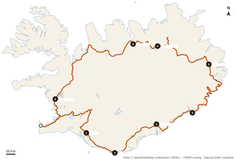
The 10-day loop, stop by stop
The direction is anticlockwise (south coast first), the most common. Times are pure driving times at legal speeds: add 15% in summer, more in strong wind or in winter.
| Day | Route | Distance | Driving |
|---|---|---|---|
| 1 | Keflavík airport → Golden Circle → Hella | 246 km | 3 h 50 |
| 2 | South coast: Seljalandsfoss, Skógafoss → Vík | 98 km | 1 h 33 |
| 3 | Vík → Fjaðrárgljúfur → Skaftafell | 146 km | 2 h 07 |
| 4 | Skaftafell → Jökulsárlón → Höfn | 127 km | 2 h 16 |
| 5 | East Fjords on Route 1 → Egilsstaðir | 263 km | 3 h 57 |
| 6 | Egilsstaðir → Dettifoss → Mývatn (Reykjahlíð) | 213 km | 3 h 04 |
| 7 | Mývatn: day on the spot | — | on the spot |
| 8 | Mývatn → Goðafoss → Akureyri | 85 km | 1 h 20 |
| 9 | Akureyri → Borgarnes (via Blönduós) | 315 km | 4 h 33 |
| 10 | Borgarnes → Keflavík airport | 120 km | 1 h 54 |
| Total | 1,615 km | 24 h 34 |
What the map shows, and what it doesn't
- Route 1 is paved all the way on this loop: a 2WD car is enough from May to October. The highland F-roads, 4x4 only and excluded from 2WD rental contracts, are not on the map: none is used.
- In the East Fjords (day 5), GPS apps often suggest Route 939 over the Öxi pass as a shortcut: it is a steep gravel track, closed in winter. The map follows Route 1 via Breiðdalsvík and Fáskrúðsfjörður.
- Fuel: on this loop, the longest stretch without a filling station is about 103 km, between Höfn and Djúpivogur (stations from OpenStreetMap, 12 October 2026). Unmanned pumps need a card with a PIN.
- Day 9 (Akureyri → Borgarnes, 315 km) is the longest: leave early and book the night in Borgarnes or closer to Reykjavík.
Every morning, before you drive
- umferdin.is: road conditions and closures (Vegagerðin, the Icelandic Road Administration)
- safetravel.is: traveller alerts
- vedur.is: weather and wind (Icelandic Met Office)
Emergency: 112.
The paper map gives the big picture. For the road itself, the roadbook in the “Iceland by car” offer details every day (stops, fuel stations on the route, the night to book) for 7, 10 or 14 days, with a GPS track per day for Organic Maps, OsmAnd or Google My Maps, plus the Golden Circle map and timetables.